
1970 Map of White
USGS Topo · Published 1972About this map
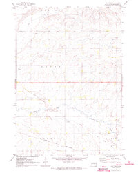
White serves as the primary hub of this eastern South Dakota landscape, appearing here as it was surveyed in the late 1960s. The town is characterized by a concentrated grid of streets, a local park, and infrastructure such as the Sewage Disposal facility, while the surrounding prairie is divided into the expansive townships of Argo, Afton, and Sherman. The transportation history of the area is etched into the terrain by an Old Railroad Grade that runs north-south, passing just east of the main settlement and skirting the shores of Oak Lake.
Find a feature on this map
17 named features on this map. Tap any name to fly to it.
Don’t see what you’re looking for? This feature index may not catch every label — zoom into the map to look around manually.
Map Details
Editions of this 1970 White Map
This is the sole edition of this map. No revisions or reprints were ever made.
Other maps of this area

1953 · Watertown
USGS Topo · 1:250,000

1958 · Watertown
USGS Topo · 1:250,000

1964 · Brookings
USGS Topo · 1:24,000

1964 · Aurora
USGS Topo · 1:24,000

1968 · Brookings NE
USGS Topo · 1:24,000

1970 · White NE
USGS Topo · 1:24,000

1970 · Astoria
USGS Topo · 1:24,000

1970 · Estelline SE
USGS Topo · 1:24,000

1970 · Toronto
USGS Topo · 1:24,000
1972 · White SE
USGS Topo · 1:24,000