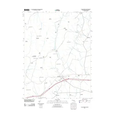
2011 Map of Clear Spring
USGS Topo · Published 2011About this map
Clear Spring and its surrounding countryside in Washington County reflect a landscape defined by traditional agriculture and early industrial roots along the Little Conococheague Creek. The presence of the Cushwa Mill near Dry Run points to the area's milling history, while the Johns Hopkins University Geological Research Station near Bear Pond Hollow highlights the region's importance for academic field study. Several established burial grounds, such as Rose Hill Cemetery and Saint Pauls Cemetery, serve as important markers for genealogists tracing local families. The map details a mix of named peaks and valleys, from Two Top Mountain in the north to the Stone Quarry Ridge in the south, illustrating how the Appalachian terrain shaped the corridor's development. Small settlements like Kasiesville, Big Spring, and Shady Bower anchor the rural road network that connects these foothills to the valley floor.
Find a feature on this map
91 named features on this map. Tap any name to fly to it.
Don’t see what you’re looking for? This feature index may not catch every label — zoom into the map to look around manually.
Map Details
Editions of this 2011 Clear Spring Map
This is the sole edition of this map. No revisions or reprints were ever made.
Other maps of this area

1899 · Hancock
USGS Topo · 1:62,500

1900 · Mercersburg
USGS Topo · 1:62,500

1901 · Hancock
USGS Topo · 1:62,500

1902 · Mercersburg
USGS Topo · 1:62,500

1912 · Williamsport
USGS Topo · 1:62,500

1925 · Needmore
USGS Topo · 1:48,000

1935 · Needmore
USGS Topo · 1:62,500

1939 · Needmore
USGS Topo · 1:62,500

1942 · Hagerstown
USGS Topo · 1:125,000

1943 · Hagerstown
USGS Topo · 1:125,000