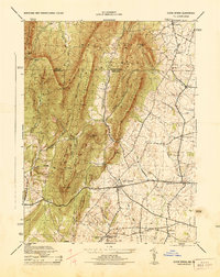
1944 Map of Clear Spring
USGS Topo · Published 1944About this map
Clear Spring serves as the focal point of this 1940s landscape, situated where the ridge-and-valley terrain of the Appalachian Mountains meets the agricultural lands of western Maryland. The map illustrates a complex network of ridges including Two Top Mountain, Sword Mountain, and Fairview Mountain, which dictate the local drainage patterns of Little Conococheague Creek and Licking Creek. The human footprint is defined by a traditional valley economy, evidenced by local hubs like Cushwa Mill and the Dry Run Store.
Find a feature on this map
54 named features on this map. Tap any name to fly to it.
Don’t see what you’re looking for? This feature index may not catch every label — zoom into the map to look around manually.
Map Details
Editions of this 1944 Clear Spring Map
This is the sole edition of this map. No revisions or reprints were ever made.
Other maps of this area

1899 · Hancock
USGS Topo · 1:62,500

1900 · Mercersburg
USGS Topo · 1:62,500

1901 · Hancock
USGS Topo · 1:62,500

1902 · Mercersburg
USGS Topo · 1:62,500

1912 · Williamsport
USGS Topo · 1:62,500

1925 · Needmore
USGS Topo · 1:48,000

1935 · Needmore
USGS Topo · 1:62,500

1939 · Needmore
USGS Topo · 1:62,500

1942 · Hagerstown
USGS Topo · 1:125,000

1943 · Hagerstown
USGS Topo · 1:125,000