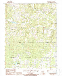
1987 Map of Clear Springs
USGS Topo · Published 1987About this map
Clear Springs and the small settlement of Hattie occupy this portion of the Ozark plateau in the late 1980s, where the landscape is defined by the winding drainages of the North Prong Jacks Fork and the South Prong Jacks Fork. The map documents a rural environment where water sources dictated land use, featuring prominent landmarks like Big Spring and the Sims Valley State Community Lake in the southern portion of the quadrangle. Local genealogy is supported by the location of several Cem sites, while place names like Rebel Hollow and Stillhouse Branch offer clues to the cultural and social history of the area near the border of Texas Co and Howell Co. The drainage network includes numerous named tributaries such as Little Pine Creek and Spargo Branch, showing the complex topography before more modern development altered the rural Missouri backcountry.
Find a feature on this map
33 named features on this map. Tap any name to fly to it.
Don’t see what you’re looking for? This feature index may not catch every label — zoom into the map to look around manually.
Map Details
Editions of this 1987 Clear Springs Map
This is the sole edition of this map. No revisions or reprints were ever made.
Other maps of this area

1945 · Willow Springs
USGS Topo · 1:62,500

1945 · Montier
USGS Topo · 1:62,500

1945 · Clear Springs
USGS Topo · 1:62,500

1946 · Summersville
USGS Topo · 1:62,500

1948 · Clear Springs
USGS Topo · 1:62,500

1948 · Montier
USGS Topo · 1:62,500

1948 · Willow Springs
USGS Topo · 1:62,500

1948 · Summersville
USGS Topo · 1:62,500

1949 · Rolla
USGS Topo · 1:250,000

1953 · Rolla
USGS Topo · 1:250,000