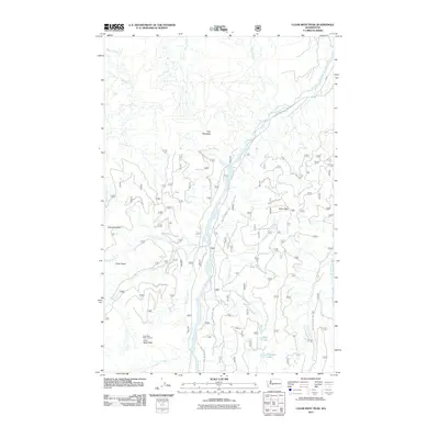
2011 Map of Clear West Peak
USGS Topo · Published 2011About this map
Clear West Peak Lookout stands as a prominent vantage point in this high-elevation terrain, overlooking the convergence of numerous alpine drainages. The landscape is defined by the West Fork White River, which carves through the center of the region, flanked by dramatic formations like The Palisades and Frog Mountain. A complex network of forest roads and trails, such as Crystal River Ranch Rd, provides access to the steep ridges and basins. The topography is dotted with small, high-altitude water bodies including Mule Lake and Lonesome Lake, which sit at the headwaters of seasonal runs like Mule Creek. In the eastern portion, Haller Pass serves as a notable transit point between the river valley and Huckleberry Creek, illustrating the challenging navigational routes required to traverse this portion of the Washington Cascades.
Find a feature on this map
28 named features on this map. Tap any name to fly to it.
Don’t see what you’re looking for? This feature index may not catch every label — zoom into the map to look around manually.
Map Details
Editions of this 2011 Clear West Peak Map
This is the sole edition of this map. No revisions or reprints were ever made.
Other maps of this area

1913 · Cedar Lake
USGS Topo · 1:125,000

1924 · Mt Rainier
USGS Topo · 1:96,000

1928 · Mt Rainier
USGS Topo · 1:125,000

1950 · Yakima
USGS Topo · 1:250,000

1956 · Greenwater
USGS Topo · 1:62,500

1956 · Enumclaw
USGS Topo · 1:62,500

1957 · Wenatchee
USGS Topo · 1:250,000

1958 · Yakima
USGS Topo · 1:250,000

1961 · Yakima
USGS Topo · 1:250,000
1971 · Sunrise
USGS Topo · 1:24,000