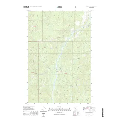
2020 Map of Clear West Peak
USGS Topo · Published 2020About this map
Snoqualmie National Forest dominates this mountain landscape, defined by sharp ridgelines and the deep incision of the West Fork White River. The terrain is characterized by prominent high points such as Three Peaks and the namesake Clear West Peak, which is accessible via the Clear West Peak Trail. The hydrology of the region is complex, with numerous tributaries like Nosedive Cr, Jim Cr, and Wrong Cr feeding into the main river valley. This 2020 survey illustrates a wilderness managed for both recreation and conservation, featuring established routes like the Frog Mountain Trail and the passage through Haller Pass. High-elevation water bodies, including Lonesome Lake and Mule Lake, sit tucked beneath features like Huckleberry Ridge, serving as landmarks for backcountry navigation in the southern Cascades.
Find a feature on this map
50 named features on this map. Tap any name to fly to it.
Don’t see what you’re looking for? This feature index may not catch every label — zoom into the map to look around manually.
Map Details
Editions of this 2020 Clear West Peak Map
This is the sole edition of this map. No revisions or reprints were ever made.
Other maps of this area

1913 · Cedar Lake
USGS Topo · 1:125,000

1924 · Mt Rainier
USGS Topo · 1:96,000

1928 · Mt Rainier
USGS Topo · 1:125,000

1950 · Yakima
USGS Topo · 1:250,000

1956 · Greenwater
USGS Topo · 1:62,500

1956 · Enumclaw
USGS Topo · 1:62,500

1957 · Wenatchee
USGS Topo · 1:250,000

1958 · Yakima
USGS Topo · 1:250,000

1961 · Yakima
USGS Topo · 1:250,000
1971 · Sunrise
USGS Topo · 1:24,000