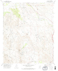
1974 Map of Cleator
USGS Topo · Published 1977About this map
Mining operations and water infrastructure define this mid-1970s landscape within the Prescott National Forest. The settlement of Cleator sits near the confluence of several seasonal drainages, including Turkey Creek and Crazy Basin Creek, where the local economy once relied heavily on mineral extraction. An Old Railroad Grade winds through the terrain, serving as a reminder of the historical transport network that once connected remote camps like the Blue Bell Mine and Jubilee Mine to the outside world. To the south and east, numerous claims such as the Golden Belt Mine, Golden Turkey Mine, and French Lilly Mine are documented alongside specialized infrastructure like the Landing Strip near Cordes. The reliance on water in this arid environment is evident from the distribution of features like Dripping Spring, Blanchard Spring, and several remote water tanks.
Find a feature on this map
42 named features on this map. Tap any name to fly to it.
Don’t see what you’re looking for? This feature index may not catch every label — zoom into the map to look around manually.
Map Details
Editions of this 1974 Cleator Map
2 editions found
Other maps of this area

1887 · Prescott
USGS Topo · 1:250,000

1892 · Prescott
USGS Topo · 1:250,000

1903 · Bradshaw Mountains
USGS Topo · 1:125,000

1947 · Crown King
USGS Topo · 1:62,500

1947 · Bumblebee
USGS Topo · 1:62,500

1947 · Mayer
USGS Topo · 1:62,500

1947 · Mt. Union
USGS Topo · 1:62,500

1948 · Bumblebee
USGS Topo · 1:63,360

1948 · Crown King
USGS Topo · 1:63,360

1948 · Mt. Union
USGS Topo · 1:63,360