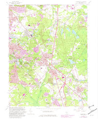
1967 Map of Clementon
USGS Topo · Published 1982About this map
The White Horse Pike and the Conrail railroad corridor form the industrial and commercial spine of this South Jersey landscape, connecting a dense string of suburban communities. To the west, the borough of Clementon is a clear center of activity, featuring the Amusement Park on the shores of Clementon Lake and the nearby Rowands Pond Wildlife Management Area. The expansion of mid-century residential tracts is evident in Lindenwold, Pine Hill, and West Berlin, where new developments appear alongside established landmarks like the West Jersey Hospital.
Find a feature on this map
108 named features on this map. Tap any name to fly to it.
Don’t see what you’re looking for? This feature index may not catch every label — zoom into the map to look around manually.
Map Details
Editions of this 1967 Clementon Map
4 editions found
Other maps of this area

1888 · Mount Holly
USGS Topo · 1:62,500

1890 · Hammonton
USGS Topo · 1:62,500

1890 · Glassboro
USGS Topo · 1:62,500

1891 · Philadelphia
USGS Topo · 1:62,500

1894 · Hammonton
USGS Topo · 1:62,500

1894 · Mount Holly
USGS Topo · 1:62,500

1894 · Philadelphia
USGS Topo · 1:62,500

1896 · Philadelphia
USGS Topo · 1:62,500

1898 · Glassboro
USGS Topo · 1:62,500

1898 · Philadelphia
USGS Topo · 1:62,500