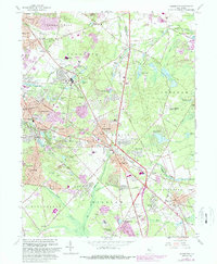
1967 Map of Clementon
USGS Topo · Published 1988About this map
Clementon and Berlin serve as the focal points for this late 1960s landscape, where suburban expansion meets the specialized agriculture of the Pinelands. The map documents a period of rapid growth, highlighted in purple revisions that show the extension of residential areas around Lindenwold and Gibbsboro. Despite the encroaching development, evidence of the region’s earlier economic base remains visible in the numerous Cranberry Bogs and the site of Tomlinson Mill along Tomlinson Mill Run.
Find a feature on this map
105 named features on this map. Tap any name to fly to it.
Don’t see what you’re looking for? This feature index may not catch every label — zoom into the map to look around manually.
Map Details
Editions of this 1967 Clementon Map
4 editions found
Other maps of this area

1888 · Mount Holly
USGS Topo · 1:62,500

1890 · Hammonton
USGS Topo · 1:62,500

1890 · Glassboro
USGS Topo · 1:62,500

1891 · Philadelphia
USGS Topo · 1:62,500

1894 · Hammonton
USGS Topo · 1:62,500

1894 · Mount Holly
USGS Topo · 1:62,500

1894 · Philadelphia
USGS Topo · 1:62,500

1896 · Philadelphia
USGS Topo · 1:62,500

1898 · Glassboro
USGS Topo · 1:62,500

1898 · Philadelphia
USGS Topo · 1:62,500