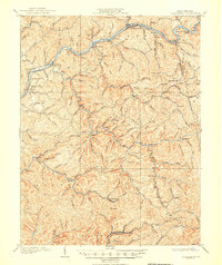
1909 Map of Clendenin
USGS Topo · Published 1950About this map
The Elk River winds through the heart of this landscape, serving as the primary corridor for commerce and travel in the early twentieth century. Along its banks, the Coal and Coke River RR provides the vital rail link that spurred development in towns like Clendenin and Queen Shoals. The topography is defined by an intricate network of deep hollows and high points, including Crabapple Knob and Mt Desert, which dictated the location of early settlements and family homesteads.
Find a feature on this map
123 named features on this map. Tap any name to fly to it.
Don’t see what you’re looking for? This feature index may not catch every label — zoom into the map to look around manually.
Map Details
Editions of this 1909 Clendenin Map
5 editions found

Other maps of this area

1897 · Kanawha Falls
USGS Topo · 1:125,000

1899 · Charleston
USGS Topo · 1:125,000

1900 · Kanawha Falls
USGS Topo · 1:125,000

1901 · Kanawha Falls
USGS Topo · 1:125,000

1906 · Kenna
USGS Topo · 1:62,500

1906 · Otter
USGS Topo · 1:62,500

1906 · Walton
USGS Topo · 1:62,500

1907 · Kenna
USGS Topo · 1:62,500

1907 · Otter
USGS Topo · 1:62,500

1907 · Walton
USGS Topo · 1:62,500