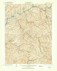
1907 Map of Clendenin
USGS Topo · Published 1965About this map
Clendenin serves as the focal point of this 1907 survey, situated at the confluence of the Elk River and Falling Rock Creek. This era captures the region's early industrial and transport framework, centered on the Coal River and Kanawha Ry corridor. The river and its numerous tributaries, including Blue Creek and Leatherwood Creek, dictate the settlement patterns of the Kanawha and Clay county borderlands. Small communities and family landmarks are densely packed into the hollows, with places like Queen Shoals, Heatherman, and Jarretts Ford marking the river's path.
Find a feature on this map
126 named features on this map. Tap any name to fly to it.
Don’t see what you’re looking for? This feature index may not catch every label — zoom into the map to look around manually.
Map Details
Editions of this 1907 Clendenin Map
2 editions found

Other maps of this area

1897 · Kanawha Falls
USGS Topo · 1:125,000

1899 · Charleston
USGS Topo · 1:125,000

1900 · Kanawha Falls
USGS Topo · 1:125,000

1901 · Kanawha Falls
USGS Topo · 1:125,000

1906 · Kenna
USGS Topo · 1:62,500

1906 · Otter
USGS Topo · 1:62,500

1906 · Walton
USGS Topo · 1:62,500

1907 · Kenna
USGS Topo · 1:62,500

1907 · Otter
USGS Topo · 1:62,500

1907 · Walton
USGS Topo · 1:62,500