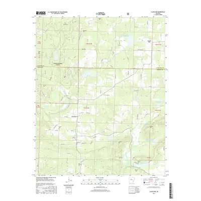
2017 Map of Cleveland
USGS Topo · Published 2017About this map
Cleveland and Gravel Hill anchor this rural landscape along the border of Van Buren and Conway counties, where the high ridges of the Ozark National Forest meet a complex network of water management reservoirs. The terrain is defined by named peaks such as Egger Mtn, Boundary Mtn, and Tar Kiln Mtn, while the drainage system of the West Fork Point Remove Creek and E Fork Point Remove Creek is dotted with numerous engineered sites like the E-Fork Point Remove Site Three Reservoir.
Find a feature on this map
74 named features on this map. Tap any name to fly to it.
Don’t see what you’re looking for? This feature index may not catch every label — zoom into the map to look around manually.
Map Details
Editions of this 2017 Cleveland Map
This is the sole edition of this map. No revisions or reprints were ever made.
Other maps of this area

1879 · Washington
USGS Topo · 1:62,500

1887 · Smyrna
USGS Topo · 1:62,500

1889 · Marshall #3
USGS Topo · 1:62,500

1892 · Marshall
USGS Topo · 1:125,000

1892 · Morrillton
USGS Topo · 1:125,000

1894 · Morrillton
USGS Topo · 1:125,000

1894 · Marshall
USGS Topo · 1:125,000

1901 · Marshall
USGS Topo · 1:125,000

1940 · Smyrna
USGS Topo · 1:62,500
1943 · Smyrna
USGS Topo · 1:62,500