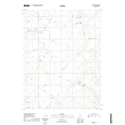
2020 Map of Cleveland
USGS Topo · Published 2020About this map
Cleveland sits at the heart of an intricate network of irrigation and desert drainage, defined by the S Br Cleveland Canal and numerous named washes that support the local ranching landscape. This modern survey illustrates the proximity of the town to the local Cleveland Cem and the small post office Po on W Main St. To the east, the landscape transitions toward the starker topography of Desert Lake and Desert Lake Wash, where the terrain is marked by prominent landmarks such as The Peaks and Big Hill. Further south, the economy and geology of the region are reflected in the presence of the Hadden Pit near the wide expanse of Hadden Flat. Researchers can trace the modern road system, including the path of Vicor Reef Rd as it winds through The Rocks toward the more remote Bull Hollow.
Find a feature on this map
60 named features on this map. Tap any name to fly to it.
Don’t see what you’re looking for? This feature index may not catch every label — zoom into the map to look around manually.
Map Details
Editions of this 2020 Cleveland Map
This is the sole edition of this map. No revisions or reprints were ever made.
Other maps of this area

1886 · Price River
USGS Topo · 1:250,000

1896 · Price River
USGS Topo · 1:250,000

1956 · Price
USGS Topo · 1:250,000

1960 · Price
USGS Topo · 1:250,000

1962 · Price
USGS Topo · 1:250,000

1969 · Olsen Reservoir
USGS Topo · 1:24,000
1969 · Bob Hill Knoll
USGS Topo · 1:24,000
1969 · Buckhorn Reservoir
USGS Topo · 1:24,000

1969 · Elmo
USGS Topo · 1:24,000
1969 · Hadden Holes
USGS Topo · 1:24,000