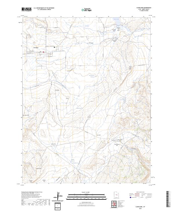
2023 Map of Cleveland
USGS Topo · Published 2023About this map
Cleveland serves as the primary residential hub in this Emery County landscape, surrounded by an intricate network of irrigation features like the South Branch Cleveland Canal and Old Ramage Pond. The town's grid is clearly defined by local landmarks such as the Cleveland Cem and the Po, while the surrounding terrain transitions into more arid geography. To the south and east, the map reveals a series of named washes and hollows, including Buffalo Hollow and Bull Hollow, which drain toward the larger Desert Lake system. Industrial and natural resource footprints are evident at the Hadden Pit near the Hadden Reservoir, situated among distinct topographic features like the Hadden Hills and The Peaks. This survey reflects the modern intersection of agricultural water management and the rugged geological formations of the San Rafael Swell's periphery.
Find a feature on this map
60 named features on this map. Tap any name to fly to it.
Don’t see what you’re looking for? This feature index may not catch every label — zoom into the map to look around manually.
Map Details
Editions of this 2023 Cleveland Map
This is the sole edition of this map. No revisions or reprints were ever made.
Other maps of this area

1886 · Price River
USGS Topo · 1:250,000

1896 · Price River
USGS Topo · 1:250,000

1956 · Price
USGS Topo · 1:250,000

1960 · Price
USGS Topo · 1:250,000

1962 · Price
USGS Topo · 1:250,000

1969 · Olsen Reservoir
USGS Topo · 1:24,000
1969 · Bob Hill Knoll
USGS Topo · 1:24,000
1969 · Buckhorn Reservoir
USGS Topo · 1:24,000

1969 · Elmo
USGS Topo · 1:24,000
1969 · Hadden Holes
USGS Topo · 1:24,000