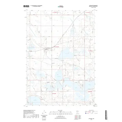
2019 Map of Cleveland
USGS Topo · Published 2019About this map
The town of Cleveland anchors this portion of Le Sueur County, situated in a landscape defined by an extensive network of lakes and managed drainage. The terrain is notably water-rich, with large bodies like Lake Jefferson and Lake Washington dominating the southern half, while the northern sections are crisscrossed by agricultural infrastructure including County Ditch Number Fiftyone and County Ditch Number Sixty. This interplay between natural hydrology and human intervention is a hallmark of the region's development.
Find a feature on this map
59 named features on this map. Tap any name to fly to it.
Don’t see what you’re looking for? This feature index may not catch every label — zoom into the map to look around manually.
Map Details
Editions of this 2019 Cleveland Map
This is the sole edition of this map. No revisions or reprints were ever made.
Other maps of this area

1950 · Mankato East
USGS Topo · 1:62,500

1951 · Mankato East
USGS Topo · 1:62,500

1953 · Saint Paul
USGS Topo · 1:250,000

1959 · Saint Paul
USGS Topo · 1:250,000

1965 · Cleveland
USGS Topo · 1:24,000
1965 · St Peter
USGS Topo · 1:24,000

1965 · Le Sueur
USGS Topo · 1:24,000

1965 · St Thomas
USGS Topo · 1:24,000

1966 · Cordova
USGS Topo · 1:24,000

1966 · Elysian
USGS Topo · 1:24,000