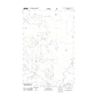
2011 Map of Cleveland Mountain
USGS Topo · Published 2011About this map
Cleveland Mountain and the high ridges of the Bitterroot Divide define this landscape in the Sapphire Mountains east of the Bitterroot Valley. The area is characterized by a dense network of drainages including Welcome Creek, Threemile Creek, and Cinnamon Bear Creek, which carve deep gulches into the terrain. Historical resource extraction and land management are evident through the presence of the Cleveland Mine and the Welcome Sawmill Saddle, indicating a legacy of prospecting and timber work in these high-elevation forests. Transportation is largely limited to Forest Service corridors like FS RD 428 and Trout Haven RD, reflecting the remote and managed nature of the land. Recreational access points, such as the Harrys Flat Campground along Rock Creek, show the area's transition into a modern wilderness and recreation destination while maintaining its traditional nomenclature rooted in local lore and geography.
Find a feature on this map
35 named features on this map. Tap any name to fly to it.
Don’t see what you’re looking for? This feature index may not catch every label — zoom into the map to look around manually.
Map Details
Editions of this 2011 Cleveland Mountain Map
This is the sole edition of this map. No revisions or reprints were ever made.
Other maps of this area

1903 · Bonner
USGS Topo · 1:125,000

1909 · Sapphire
USGS Topo · 1:125,000

1947 · Butte
USGS Topo · 1:250,000

1958 · Butte
USGS Topo · 1:250,000

1959 · Cleveland Mountain
USGS Topo · 1:62,500

1959 · Ravenna
USGS Topo · 1:62,500

1960 · Butte
USGS Topo · 1:250,000

1962 · Butte
USGS Topo · 1:250,000
1974 · Sawmill Saddle
USGS Topo · 1:24,000
1975 · Quigg Peak
USGS Topo · 1:24,000