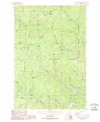
1989 Map of Cleveland Mountain
USGS Topo · Published 1989About this map
Cleveland Mountain rises as the central landmark of this high-elevation Montana landscape, marking the rugged boundary between Bitterroot National Forest and Lolo National Forest. The map documents a heavily forested wilderness at the edge of the Bitterroot Divide, where the county line separates Ravalli and Granite counties. Mining history is evident at the Cleveland Mine situated just north of the peak, while modern land usage is reflected in the extensive Welcome Creek Wilderness and the State Wildlife Management Area in the northwest. Drainages like Welcome Creek, Ambrose Creek, and Rock Creek carve deep through the terrain, punctuated by named crossings and high points such as Cinnamon Bear Saddle and Cinnabar Point.
Find a feature on this map
36 named features on this map. Tap any name to fly to it.
Don’t see what you’re looking for? This feature index may not catch every label — zoom into the map to look around manually.
Map Details
Editions of this 1989 Cleveland Mountain Map
This is the sole edition of this map. No revisions or reprints were ever made.
Other maps of this area

1903 · Bonner
USGS Topo · 1:125,000

1909 · Sapphire
USGS Topo · 1:125,000

1947 · Butte
USGS Topo · 1:250,000

1958 · Butte
USGS Topo · 1:250,000

1959 · Cleveland Mountain
USGS Topo · 1:62,500

1959 · Ravenna
USGS Topo · 1:62,500

1960 · Butte
USGS Topo · 1:250,000

1962 · Butte
USGS Topo · 1:250,000
1974 · Sawmill Saddle
USGS Topo · 1:24,000
1975 · Quigg Peak
USGS Topo · 1:24,000