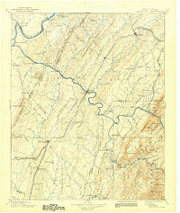
1981 Map of Cleveland
USGS Topo · Published 1981About this map
Cleveland and Athens anchor the industrial and agricultural landscape of Southeast Tennessee in this early 1980s Tennessee Valley Authority study. The map illustrates a region defined by its hydro-electric and mining legacy, from the Apalachia Powerhouse on the Ocoee River to the distinct industrial footprint of the Copper Basin near Copperhill and Ducktown. The terrain transitions from the ridge-and-valley patterns of Mouse Creek Ridge to the high elevations of the Unicor Mountains and Starr Mountain, highlighting the extensive reach of the Cherokee National Forest.
Find a feature on this map
185 named features on this map. Tap any name to fly to it.
Don’t see what you’re looking for? This feature index may not catch every label — zoom into the map to look around manually.
Map Details
Editions of this 1981 Cleveland Map
2 editions found
Historical Maps of Cleveland Through Time
5 maps found