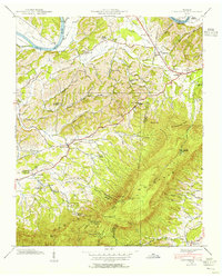
1939 Map of Clevenger
USGS Topo · Published 1954About this map
The French Broad River flows through the northern reaches of this East Tennessee landscape, winding past Swann Island and Taylor Bend near the Dutch Bottoms. This 1939 field survey captures a rural network of small communities and crossroads settlements defined by the convergence of Jefferson, Cocke, and Sevier counties. The rugged southern terrain is dominated by English Mountain, where landmarks like The Pinnacle, Split Gap, and a Lookout Tower provide vantage points over the numerous hollows and branches below.
Find a feature on this map
79 named features on this map. Tap any name to fly to it.
Don’t see what you’re looking for? This feature index may not catch every label — zoom into the map to look around manually.
Map Details
Editions of this 1939 Clevenger Map
This is the sole edition of this map. No revisions or reprints were ever made.
Other maps of this area

1883 · Morristown
USGS Topo · 1:125,000

1893 · Mt Guyot
USGS Topo · 1:125,000

1893 · Morristown
USGS Topo · 1:125,000

1895 · Morristown
USGS Topo · 1:125,000

1912 · Mt Guyot
USGS Topo · 1:125,000

1935 · Newport
USGS Topo · 1:48,000

1935 · White Pine
USGS Topo · 1:24,000

1935 · Hartford
USGS Topo · 1:24,000

1935 · English Mountain
USGS Topo · 1:48,000

1935 · Clevenger
USGS Topo · 1:24,000