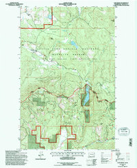
1992 Map of Cliff Ridge
USGS Topo · Published 1996About this map
Stevens County's mountainous interior is defined here by the meeting of protected lands and resource extraction. The Colville National Forest dominates the southern half, while the Little Pend Oreille National Wildlife Refuge and Little Pend Oreille State Wildlife Area cover the northern elevations. Between the peaks of Cliff Ridge and McDonald Mtn, several smaller lakes including Starvation Lake and McDowell Lake dot the drainages of the Little Pend Oreille River. Human history is marked by the Bingville site and the Narcisse Sch in the north, alongside traces of industry such as the Perry Mine and a Quarry near Brewer Mtn. The landscape transitioned in the late twentieth century toward conservation, centered around the Wildlife Refuge Headquarters and managed forest lands.
Find a feature on this map
28 named features on this map. Tap any name to fly to it.
Don’t see what you’re looking for? This feature index may not catch every label — zoom into the map to look around manually.
Map Details
Editions of this 1992 Cliff Ridge Map
This is the sole edition of this map. No revisions or reprints were ever made.
Other maps of this area

1927 · Chewelah
USGS Topo · 1:125,000

1929 · Colville
USGS Topo · 1:125,000

1930 · Chewelah
USGS Topo · 1:125,000

1933 · Colville
USGS Topo · 1:125,000

1952 · White Mud Lake
USGS Topo · 1:24,000

1958 · Sandpoint
USGS Topo · 1:250,000

1963 · Sandpoint
USGS Topo · 1:250,000

1964 · Chewelah
USGS Topo · 1:24,000

1964 · Cliff Ridge
USGS Topo · 1:24,000
1964 · Calispell Peak
USGS Topo · 1:24,000