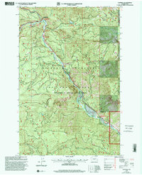
2000 Map of Cliffdell
USGS Topo · Published 2001About this map
The Naches River corridor defines this mountain landscape, serving as the primary artery for travel and recreation at the turn of the millennium. The small community of Cliffdell and the nearby settlement of Pinecliff anchor the valley along Route 410, which follows the river's path through the Mt Baker-Snoqualmie National Forest. This area is a dense hub of mid-century and modern outdoor institutional life, featuring Camp Roganunda, Christian Camp, and Mountain Air Camp clustered near the water.
Find a feature on this map
32 named features on this map. Tap any name to fly to it.
Don’t see what you’re looking for? This feature index may not catch every label — zoom into the map to look around manually.
Map Details
Editions of this 2000 Cliffdell Map
This is the sole edition of this map. No revisions or reprints were ever made.
Other maps of this area

1897 · Mount Stuart
USGS Topo · 1:125,000

1899 · Ellensburg
USGS Topo · 1:125,000

1901 · Ellensburg
USGS Topo · 1:125,000

1901 · Snoqualmie Pass
USGS Topo · 1:125,000

1902 · Mount Aix
USGS Topo · 1:125,000

1902 · Mount Stuart
USGS Topo · 1:125,000

1903 · Snoqualmie
USGS Topo · 1:125,000

1904 · Mt Aix
USGS Topo · 1:125,000

1950 · Yakima
USGS Topo · 1:250,000

1957 · Wenatchee
USGS Topo · 1:250,000