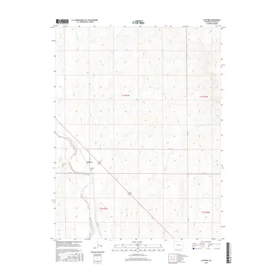
2016 Map of Clifford
USGS Topo · Published 2016About this map
Clifford sits at a strategic junction in Lincoln County where the winding path of Big Sandy Creek meets a network of local transit corridors. This prairie landscape is defined by the ephemeral drainages of Coon Cr and Sevenmile Cr, which carve subtle topography through the high plains. The settlement itself is small, marked by its proximity to the rural cemetery at Clifford Cem, a vital site for local genealogical research. The layout of the land is strictly governed by the Public Land Survey System, with township boundaries like t11s r53w and t12s r52w forming the rectilinear grid that dictates the placement of county roads. Modern infrastructure, including CO Hwy 63 and CO Rd 38, follows these section lines, illustrating how twentieth-century transportation patterns were built directly upon the nineteenth-century survey foundations.
Find a feature on this map
14 named features on this map. Tap any name to fly to it.
Don’t see what you’re looking for? This feature index may not catch every label — zoom into the map to look around manually.
Map Details
Editions of this 2016 Clifford Map
This is the sole edition of this map. No revisions or reprints were ever made.
Other maps of this area

1891 · Arroyo
USGS Topo · 1:125,000

1893 · Arroyo
USGS Topo · 1:125,000

1954 · Limon
USGS Topo · 1:250,000

1954 · Lamar
USGS Topo · 1:250,000

1957 · Limon
USGS Topo · 1:250,000

1958 · Limon
USGS Topo · 1:250,000

1958 · Lamar
USGS Topo · 1:250,000
1978 · Kinney Lake
USGS Topo · 1:24,000
1978 · Boyero
USGS Topo · 1:24,000

1978 · Clifford
USGS Topo · 1:24,000