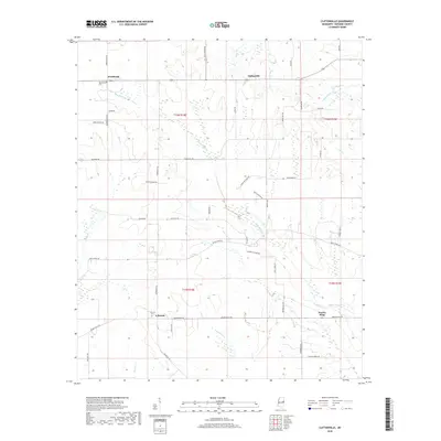
2018 Map of Cliftonville
USGS Topo · Published 2018About this map
Deerbrook and Cliftonville occupy the high ground of the northeast Mississippi prairie in this detailed 2018 survey. The landscape is defined by the headwaters and meandering branches of Bogue Chitto, which cuts across the central portion of the map. This area of Noxubee County exhibits a traditional Southern land pattern, where small settlements like X-Prairie are connected by a network of established roads such as Old Macon Rd and Buggs Ferry Rd. The survey meticulously documents the township and range boundaries, including t16n r18e and t16n r19e, which provide a reliable grid for local historians and genealogists tracking property lines in this agricultural region.
Find a feature on this map
7 named features on this map. Tap any name to fly to it.
Don’t see what you’re looking for? This feature index may not catch every label — zoom into the map to look around manually.
Map Details
Editions of this 2018 Cliftonville Map
This is the sole edition of this map. No revisions or reprints were ever made.
Other maps of this area

1953 · West Point
USGS Topo · 1:250,000

1958 · West Point
USGS Topo · 1:250,000

1959 · Artesia
USGS Topo · 1:62,500

1960 · Columbus
USGS Topo · 1:62,500

1963 · West Point
USGS Topo · 1:250,000

1973 · Cliftonville
USGS Topo · 1:24,000

1973 · McLeod
USGS Topo · 1:24,000
1973 · Brooksville
USGS Topo · 1:24,000
1973 · Macon
USGS Topo · 1:24,000
1974 · Dancy
USGS Topo · 1:24,000