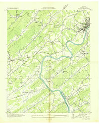
1936 Map of Clinton
USGS Topo · Published 1936About this map
The Clinch River carves a sinuous path through this 1936 survey, defining a landscape dominated by the parallel ridges of Walden Ridge and Black Oak Ridge. In the northeast, the county seat of Clinton serves as a nexus for the Southern Ry and Louisville and Nashville RR, while smaller clusters like South Clinton and Marlow trace the valley floors. This era before massive industrial transformation shows a patchwork of rural holdings, where Spessard Mill and College Hill stand as local landmarks alongside numerous family burial grounds like Patterson Cem and Hendren Cem.
Find a feature on this map
72 named features on this map. Tap any name to fly to it.
Don’t see what you’re looking for? This feature index may not catch every label — zoom into the map to look around manually.
Map Details
Editions of this 1936 Clinton Map
This is the sole edition of this map. No revisions or reprints were ever made.
Other maps of this area

1893 · Briceville
USGS Topo · 1:125,000

1895 · Loudon
USGS Topo · 1:125,000

1895 · Briceville
USGS Topo · 1:125,000

1896 · Briceville
USGS Topo · 1:125,000

1935 · Bethel Valley
USGS Topo · 1:24,000

1935 · Bearden
USGS Topo · 1:24,000

1935 · Lovell
USGS Topo · 1:24,000

1936 · Duncan Flats
USGS Topo · 1:24,000

1936 · Windrock
USGS Topo · 1:24,000

1936 · Norris Dam
USGS Topo · 1:48,000