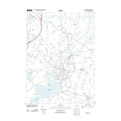
2012 Map of Clinton
USGS Topo · Published 2012About this map
Wachusett Reservoir dominates the southern landscape, its northern shoreline defined by Cemetery Island, Sawyer Bluff, and the Carville Basin. This 2012 survey illustrates the dense residential and institutional development surrounding the town of Clinton, where historic burial grounds like Saint Johns Cem and Woodlawn Cem are situated alongside the N Nashua River. To the north, the settlement of Lancaster serves as a hub for academic and religious centers including Atlantic Union College and the Seventh Day Adventist Village. The map details a sophisticated water management network, tracing the path of the Cosgrove Aqueduct near West Berlin and identifying numerous agricultural landmarks such as Apple Lane Orchard and Meadowbrook Orchards. Significant geographic elevation changes are marked by numerous named peaks, including Wekepeke Hill and Wataquadock Hill, which overlook the winding course of the Still River.
Find a feature on this map
206 named features on this map. Tap any name to fly to it.
Don’t see what you’re looking for? This feature index may not catch every label — zoom into the map to look around manually.
Map Details
Editions of this 2012 Clinton Map
This is the sole edition of this map. No revisions or reprints were ever made.
Other maps of this area

1885 · Worcester
USGS Topo · 1:62,500

1886 · Worcester
USGS Topo · 1:62,500

1887 · Marlboro
USGS Topo · 1:62,500

1887 · Fitchburg
USGS Topo · 1:62,500

1889 · Marlboro
USGS Topo · 1:62,500

1889 · Fitchburg
USGS Topo · 1:62,500

1892 · Worcester
USGS Topo · 1:62,500

1893 · Fitchburg
USGS Topo · 1:62,500

1893 · Groton
USGS Topo · 1:62,500

1896 · Marlboro
USGS Topo · 1:62,500