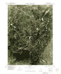
1975 Map of Clinton
USGS Topo · Published 1981About this map
The Wachusett Reservoir dominates the southern landscape of this 1975 orthophotograph, its intricate shoreline and submerged valleys starkly visible beneath the water's surface. This aerial survey, captured by the Geological Survey and the Commonwealth of Massachusetts Department of Public Works, provides a photographic record of the industrial and residential development in Clinton and Lancaster. The transition from the dense urban grid of Clinton to the more dispersed patterns in South Lancaster and Five Corners reveals the region’s mid-century expansion.
Find a feature on this map
9 named features on this map. Tap any name to fly to it.
Don’t see what you’re looking for? This feature index may not catch every label — zoom into the map to look around manually.
Map Details
Editions of this 1975 Clinton Map
This is the sole edition of this map. No revisions or reprints were ever made.
Other maps of this area

1885 · Worcester
USGS Topo · 1:62,500

1886 · Worcester
USGS Topo · 1:62,500

1887 · Marlboro
USGS Topo · 1:62,500

1887 · Fitchburg
USGS Topo · 1:62,500

1889 · Marlboro
USGS Topo · 1:62,500

1889 · Fitchburg
USGS Topo · 1:62,500

1892 · Worcester
USGS Topo · 1:62,500

1893 · Fitchburg
USGS Topo · 1:62,500

1893 · Groton
USGS Topo · 1:62,500

1896 · Marlboro
USGS Topo · 1:62,500