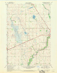
1968 Map of Clontarf South
USGS Topo · Published 1970About this map
The Chippewa River meanders through the southern portion of this West Central Minnesota landscape, defining a terrain shaped by post-glacial prairie potholes and extensive marshlands. The Great Northern railroad corridor serves as the primary developmental axis, cutting diagonally across the map to link the village of Clontarf with regional hubs. This survey illustrates a rural economy focused on conservation and water management, highlighted by the sprawling Danvers State Wildlife Management Area and the National Wildlife Management Area surrounding Lynch Lake. Genealogists will find local landmarks such as Townhall in the southwest and the Six Mile Grove Cem near the river, while industry is noted by the Benson Airport and a solitary Powerplant on the eastern edge. A network of drainage ditches, including Judicial Ditch No. 1 and No. 8, reveals the early 20th-century effort to reclaim this wetland for agriculture.
Find a feature on this map
17 named features on this map. Tap any name to fly to it.
Don’t see what you’re looking for? This feature index may not catch every label — zoom into the map to look around manually.
Map Details
Editions of this 1968 Clontarf South Map
This is the sole edition of this map. No revisions or reprints were ever made.
Other maps of this area

1953 · Saint Cloud
USGS Topo · 1:250,000

1957 · Saint Cloud
USGS Topo · 1:250,000

1958 · Saint Cloud
USGS Topo · 1:250,000

1958 · Gracelock NE
USGS Topo · 1:24,000

1958 · Big Bend City
USGS Topo · 1:24,000

1958 · Gracelock NW
USGS Topo · 1:24,000

1968 · Danvers
USGS Topo · 1:24,000

1968 · Hancock
USGS Topo · 1:24,000

1968 · Lake Hassel
USGS Topo · 1:24,000

1968 · Benson
USGS Topo · 1:24,000