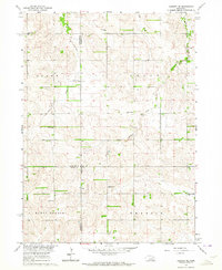
1963 Map of Closter NE
USGS Topo · Published 1964About this map
The rolling agricultural divide between Antelope and Madison counties is defined by a dense network of early rural educational centers. In the early 1960s, these small country schools, such as Honeysett Sch and Morning Star Sch, were still notable landmarks across the townships of Grant and Grove. This area, mapped for the Missouri River Basin development program, showcases a landscape of section-line roads and family-named features like Bunker Hill.
Find a feature on this map
22 named features on this map. Tap any name to fly to it.
Don’t see what you’re looking for? This feature index may not catch every label — zoom into the map to look around manually.
Map Details
Editions of this 1963 Closter NE Map
2 editions found
Other maps of this area

1955 · Sioux City
USGS Topo · 1:250,000

1955 · Fremont
USGS Topo · 1:250,000

1957 · Fremont
USGS Topo · 1:250,000

1958 · Sioux City
USGS Topo · 1:250,000

1958 · Fremont
USGS Topo · 1:250,000

1959 · Sioux City
USGS Topo · 1:250,000

1963 · Closter SW
USGS Topo · 1:24,000
1963 · Oakdale
USGS Topo · 1:24,000

1963 · Emerick
USGS Topo · 1:24,000

1963 · Meadow Grove
USGS Topo · 1:24,000