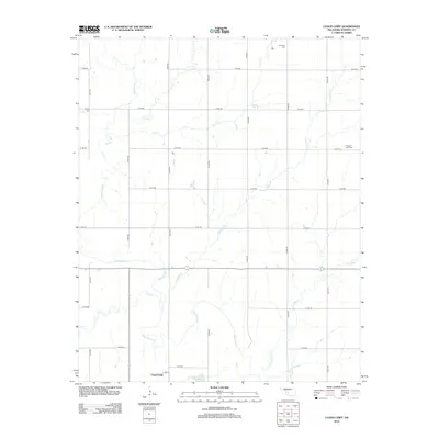
2012 Map of Cloud Chief
USGS Topo · Published 2012About this map
The Washita River snakes across this Washita County landscape, defining the local drainage patterns and physical geography of western Oklahoma. The settlement of Cloud Chief serves as a central point of interest in the southern portion of the quadrangle, an area characterized by the intersection of rural section roads and winding watercourses. Significant tributaries like Coffee Cr and Corn Cr feed into the river system, illustrating the dendritic network that has supported agricultural life in this region for generations. This 2012 survey captures the layout of the land long after the initial settlement period, showing how the local road grid accommodates the natural meandering paths of the river and its smaller creeks.
Find a feature on this map
4 named features on this map. Tap any name to fly to it.
Don’t see what you’re looking for? This feature index may not catch every label — zoom into the map to look around manually.
Map Details
Editions of this 2012 Cloud Chief Map
This is the sole edition of this map. No revisions or reprints were ever made.
Other maps of this area

1955 · Clinton
USGS Topo · 1:250,000

1956 · Cordell
USGS Topo · 1:62,500

1957 · Clinton
USGS Topo · 1:250,000

1961 · Gotebo
USGS Topo · 1:62,500

1961 · Eakly
USGS Topo · 1:62,500

1961 · Carnegie
USGS Topo · 1:62,500
1983 · Bessie
USGS Topo · 1:24,000
1983 · Corn
USGS Topo · 1:24,000
1983 · Cordell
USGS Topo · 1:24,000

1983 · Cloud Chief
USGS Topo · 1:24,000