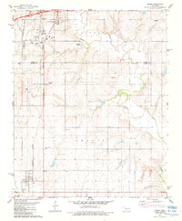
1983 Map of Bessie
USGS Topo · Published 1984About this map
The Washita River snakes through the center of this Western Oklahoma landscape, marking the transition between the southern edge of Clinton and the smaller community of Bessie. The northern section is defined by a dense transportation and utility corridor where the Atchison Topeka and Santa Fe and Burlington Northern railroads intersect near the Fransen Siding. Significant local institutions are documented here, including the Oklahoma Veterans Center and several rural sanctuaries such as Chapel Hill Ch and Peace Ch.
Find a feature on this map
27 named features on this map. Tap any name to fly to it.
Don’t see what you’re looking for? This feature index may not catch every label — zoom into the map to look around manually.
Map Details
Editions of this 1983 Bessie Map
This is the sole edition of this map. No revisions or reprints were ever made.
Other maps of this area

1955 · Clinton
USGS Topo · 1:250,000

1956 · Cordell
USGS Topo · 1:62,500

1957 · Clinton
USGS Topo · 1:250,000

1957 · Butler
USGS Topo · 1:62,500

1957 · Clinton
USGS Topo · 1:62,500

1957 · Dill City
USGS Topo · 1:62,500

1976 · Clinton SE
USGS Topo · 1:24,000

1976 · Dill City SE
USGS Topo · 1:24,000

1976 · Clinton SW
USGS Topo · 1:24,000
1976 · Butler SE
USGS Topo · 1:24,000