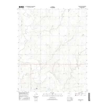
2016 Map of Cloud Chief
USGS Topo · Published 2016About this map
The Washita River winds through the heart of this Washita County landscape, anchoring a rural region defined by its creek valleys and agricultural grid. The settlement of Corn occupies the northern edge, while Cloud Chief is situated further south, representing long-standing communities in the Oklahoma plains. Local heritage is preserved in several community burial grounds, including the Brethren Cem, Shelley Cem, and Pleasant View Cem, which provide specific points of interest for genealogical research. The topography is shaped by numerous waterways such as Corn Cr, Two Baby Cr, and Friendship Cr, alongside the managed waters of the Oak Cr Site 10 Reservoir. The extensive section-line road network, from e1140 RD to E 1216 RD, illustrates the systematic development of the territory and its continued reliance on these transit corridors for connectivity between local farmsteads and town centers.
Find a feature on this map
28 named features on this map. Tap any name to fly to it.
Don’t see what you’re looking for? This feature index may not catch every label — zoom into the map to look around manually.
Map Details
Editions of this 2016 Cloud Chief Map
This is the sole edition of this map. No revisions or reprints were ever made.
Other maps of this area

1955 · Clinton
USGS Topo · 1:250,000

1956 · Cordell
USGS Topo · 1:62,500

1957 · Clinton
USGS Topo · 1:250,000

1961 · Gotebo
USGS Topo · 1:62,500

1961 · Eakly
USGS Topo · 1:62,500

1961 · Carnegie
USGS Topo · 1:62,500
1983 · Bessie
USGS Topo · 1:24,000
1983 · Corn
USGS Topo · 1:24,000
1983 · Cordell
USGS Topo · 1:24,000

1983 · Cloud Chief
USGS Topo · 1:24,000