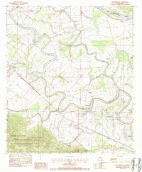
1983 Map of Cloutierville
USGS Topo · Published 1984About this map
The alluvial plains of the Natchitoches Parish river country are defined here by the winding course of the Cane River Lake and the Red River. This early 1980s landscape is deeply agricultural, with a settlement pattern that follows the water, including the historic community of Cloutierville and the railroad stop at Derry. The map reveals the intricate network of parish life through its numerous religious and educational sites, such as St Augustine Ch near Melrose and Spring Hill Ch in the south. To the southwest, the terrain shifts abruptly as the flat bottomlands meet the rising elevations of the Kisatchie National Forest, specifically the Kisatchie Hills Wilderness Area and the Red Dirt National Wildlife Management Preserve. Transportation is anchored by the Missouri Pacific railroad line, which parallels the river and serves the scattered hamlets of Montrose and Magnolia.
Find a feature on this map
47 named features on this map. Tap any name to fly to it.
Don’t see what you’re looking for? This feature index may not catch every label — zoom into the map to look around manually.
Map Details
Editions of this 1983 Cloutierville Map
3 editions found
Other maps of this area

1935 · Verda
USGS Topo · 1:31,680

1937 · Chopin NE
USGS Topo · 1:31,680

1937 · Bermuda
USGS Topo · 1:31,680

1937 · Chopin NW
USGS Topo · 1:31,680

1937 · Aloha
USGS Topo · 1:31,680

1937 · Montgomery
USGS Topo · 1:62,500

1937 · Cloutierville
USGS Topo · 1:31,680

1937 · Cypress
USGS Topo · 1:31,680

1942 · Kisatchie
USGS Topo · 1:62,500

1942 · Montgomery
USGS Topo · 1:62,500