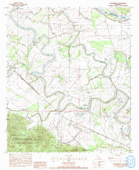
1983 Map of Cloutierville
USGS Topo · Published 1991About this map
The Cane River Lake meanders through the heart of this alluvial landscape, marking the historic path of the Red River before its course shifted. Established settlements such as Cloutierville and Melrose line the banks, reflecting the long-standing plantation culture and community life of Natchitoches Parish. The map reveals a dense concentration of cultural landmarks, from St Augustine Ch near Melrose to the Spring Hill Ch further south, illustrating the importance of parish life in these river communities.
Find a feature on this map
44 named features on this map. Tap any name to fly to it.
Don’t see what you’re looking for? This feature index may not catch every label — zoom into the map to look around manually.
Map Details
Editions of this 1983 Cloutierville Map
3 editions found
Other maps of this area

1935 · Verda
USGS Topo · 1:31,680

1937 · Chopin NE
USGS Topo · 1:31,680

1937 · Bermuda
USGS Topo · 1:31,680

1937 · Chopin NW
USGS Topo · 1:31,680

1937 · Aloha
USGS Topo · 1:31,680

1937 · Montgomery
USGS Topo · 1:62,500

1937 · Cloutierville
USGS Topo · 1:31,680

1937 · Cypress
USGS Topo · 1:31,680

1942 · Kisatchie
USGS Topo · 1:62,500

1942 · Montgomery
USGS Topo · 1:62,500