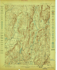
1898 Map of Clove
USGS Topo · Published 1898About this map
The Harlem Division and the Dutchess and Connecticut Railroad define the transport corridors of eastern Dutchess County during the late nineteenth century. This topography is dominated by the steep ridges of Schaghticoke Mt. and Chestnut Ridge, which frame the agricultural and industrial valleys. Settlement patterns reveal a landscape transitioning from rural crossroads like Crouses Store to established villages such as Dover Plains and Pawling.
Find a feature on this map
72 named features on this map. Tap any name to fly to it.
Don’t see what you’re looking for? This feature index may not catch every label — zoom into the map to look around manually.
Map Details
Editions of this 1898 Clove Map
This is the sole edition of this map. No revisions or reprints were ever made.
Other maps of this area

1892 · West Point
USGS Topo · 1:62,500
1892 · Danbury
USGS Topo · 1:62,500
1892 · Cornwall
USGS Topo · 1:62,500
1892 · New Milford
USGS Topo · 1:62,500

1892 · Carmel
USGS Topo · 1:62,500

1893 · Carmel
USGS Topo · 1:62,500
1893 · New Milford
USGS Topo · 1:62,500
1893 · Cornwall
USGS Topo · 1:62,500
1893 · Clove
USGS Topo · 1:62,500
1893 · Poughkeepsie
USGS Topo · 1:62,500