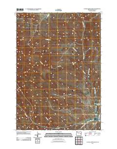
2011 Map of Clover Creek Ranch
USGS Topo · Published 2011About this map
Cover Creek Ranch serves as a primary point of reference in this arid region of eastern Oregon, where a complex network of seasonal drainages defines the remote landscape. The movement of water through the high desert is traced by the paths of North Clover Creek, Spaulding Creek, and Post Creek, which eventually converge as they flow toward the southeast. The infrastructure of the area is largely defined by rural corridors such as Upper Clover Creek Rd and Bonita Rd, which facilitate access to remote livestock operations and the Wheaton Creek Reservoir. In the southern portion of the quadrangle, the convergence of Smith Creek and Clover Creek near the depression of Brushy Hollow illustrates the fundamental relationship between hydrology and land use in Malheur County.
Find a feature on this map
12 named features on this map. Tap any name to fly to it.
Don’t see what you’re looking for? This feature index may not catch every label — zoom into the map to look around manually.
Map Details
Editions of this 2011 Clover Creek Ranch Map
This is the sole edition of this map. No revisions or reprints were ever made.
Other maps of this area

1908 · Ironside Mountain
USGS Topo · 1:125,000

1955 · Baker
USGS Topo · 1:250,000

1955 · Canyon City
USGS Topo · 1:250,000

1959 · Baker
USGS Topo · 1:250,000

1959 · Canyon City
USGS Topo · 1:250,000

1964 · Ironside
USGS Topo · 1:62,500

1966 · Clover Creek Ranch
USGS Topo · 1:62,500

1970 · Castle Rock
USGS Topo · 1:62,500
1972 · Eldorado Pass
USGS Topo · 1:24,000

1978 · John Day
USGS Topo · 1:100,000