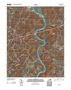
2010 Map of Clover
USGS Topo · Published 2010About this map
The settlement of Clover and its surrounding rural landscape define this section of Halifax County, Virginia, situated along a prominent bend in the Roanoke River. The map illustrates a region where local industry and transportation networks intersect with a complex system of waterways. Significant features include the Burlington Industries Dam and the riverside community of Public Fork. Genealogists and local historians can locate the Saint Matthews Cemetery northwest of the main town site, while the landscape is heavily articulated by numerous watercourses, including Clover Creek, Ashcake Creek, and Difficult Creek. The presence of Clover Landing on the banks of the Roanoke suggests the enduring importance of the river to the area's development and access. The terrain is further detailed by the convergence of smaller tributaries like Tanyard Branch and Opossum Branch, which feed into the larger river system that dominates the eastern portion of the quadrangle.
Find a feature on this map
25 named features on this map. Tap any name to fly to it.
Don’t see what you’re looking for? This feature index may not catch every label — zoom into the map to look around manually.
Map Details
Editions of this 2010 Clover Map
This is the sole edition of this map. No revisions or reprints were ever made.
Other maps of this area

1941 · Clarksville
USGS Topo · 1:48,000

1943 · Clarksville
USGS Topo · 1:62,500

1953 · South Boston
USGS Topo · 1:62,500

1953 · Greensboro
USGS Topo · 1:250,000

1954 · Greensboro
USGS Topo · 1:250,000

1954 · Clover
USGS Topo · 1:62,500

1954 · Halifax
USGS Topo · 1:62,500

1957 · South Boston
USGS Topo · 1:62,500

1957 · Clarksville
USGS Topo · 1:62,500

1962 · Greensboro
USGS Topo · 1:250,000