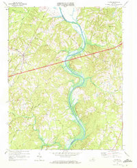
1968 Map of Clover
USGS Topo · Published 1972About this map
The Roanoke River snakes through the center of this Virginia landscape, where it is designated as the John H Kerr Reservoir. The boundary between Halifax Co and Charlotte Co follows the centerline of this water body, which defines the local topography of steep draws and winding creek branches. To the west, the community of Clover serves as a local hub, situated along the Southern railroad line. This settlement is characterized by institutional landmarks including the Halifax Co Academy, St Matthews Ch, and a prominent Radio Tower.
Find a feature on this map
33 named features on this map. Tap any name to fly to it.
Don’t see what you’re looking for? This feature index may not catch every label — zoom into the map to look around manually.
Map Details
Editions of this 1968 Clover Map
3 editions found
Other maps of this area

1941 · Clarksville
USGS Topo · 1:48,000

1943 · Clarksville
USGS Topo · 1:62,500

1953 · South Boston
USGS Topo · 1:62,500

1953 · Greensboro
USGS Topo · 1:250,000

1954 · Greensboro
USGS Topo · 1:250,000

1954 · Clover
USGS Topo · 1:62,500

1954 · Halifax
USGS Topo · 1:62,500

1957 · South Boston
USGS Topo · 1:62,500

1957 · Clarksville
USGS Topo · 1:62,500

1962 · Greensboro
USGS Topo · 1:250,000