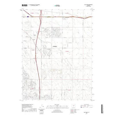
2019 Map of Coal Creek
USGS Topo · Published 2019About this map
Aurora is shown during a period of modern expansion along the high plains east of Denver, where suburban development meets the drainage basins of the South Platte River system. This landscape is defined by the winding paths of Coal Creek and Murphy Cr, which carve through the terrain beneath the expansive flight patterns of Buckley Air Force Base. The map documents the intricate grid of residential streets pushing eastward, contrasted by established landmarks like the Saint Simeon Catholic Cem and the small residential enclave of Aetna Estates near the northern boundary. While the map illustrates a highly developed suburban network, the underlying topography reveals the natural draws of First Cr and Senac Cr, showing how the modern city has integrated with the historical prairie hydrology. The presence of Simons Airport and major transport corridors like Frontage Rd highlights the area's role as a critical hub for regional infrastructure.
Find a feature on this map
111 named features on this map. Tap any name to fly to it.
Don’t see what you’re looking for? This feature index may not catch every label — zoom into the map to look around manually.
Map Details
Editions of this 2019 Coal Creek Map
This is the sole edition of this map. No revisions or reprints were ever made.
Other maps of this area

1890 · East Denver
USGS Topo · 1:125,000

1935 · East Denver Nos. 3 and 4
USGS Topo · 1:48,000

1938 · Long Branch
USGS Topo · 1:24,000

1939 · Coal Creek
USGS Topo · 1:24,000

1940 · Piney Creek
USGS Topo · 1:24,000

1941 · Long Branch
USGS Topo · 1:31,680

1941 · Fitzsimons
USGS Topo · 1:31,680

1942 · Box Elder School
USGS Topo · 1:31,680

1942 · Parker
USGS Topo · 1:31,680

1942 · Piney Creek
USGS Topo · 1:31,680