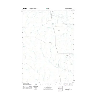
2012 Map of Coal Springs SW
USGS Topo · Published 2012About this map
Duncan Butte dominates the high plains of Perkins County in this 2012 survey, standing as a prominent landmark amidst the headwaters of the regional drainage system. The terrain is defined by its series of distinct high points, including Wedgetent Butte and Curiosity Butte, which overlook a network of seasonal watercourses. These drainages, such as Thunder Butte Cr and Cottonwood Cr, carve subtle pathways across the landscape, reflecting the classic topography of the South Dakota plains. A handful of local routes, specifically Foster Rd and Happy Hill Rd, provide the only formal access through this ranching country. The presence of named features like Boggy Draw suggests the environmental challenges faced by those traversing the area between the forks of Porcupine Cr and Duncan Cr.
Find a feature on this map
10 named features on this map. Tap any name to fly to it.
Don’t see what you’re looking for? This feature index may not catch every label — zoom into the map to look around manually.
Map Details
Editions of this 2012 Coal Springs SW Map
This is the sole edition of this map. No revisions or reprints were ever made.
Other maps of this area

1951 · Faith NE
USGS Topo · 1:24,000

1952 · Deep Creek NE
USGS Topo · 1:24,000

1952 · Faith NW
USGS Topo · 1:24,000

1954 · Lemmon
USGS Topo · 1:250,000

1957 · Lemmon
USGS Topo · 1:250,000

1983 · Coal Springs
USGS Topo · 1:24,000

1983 · Sunrise Butte
USGS Topo · 1:24,000

1983 · Coal Springs SW
USGS Topo · 1:24,000
1983 · Coal Springs SE
USGS Topo · 1:24,000

1983 · Coal Springs NW
USGS Topo · 1:24,000