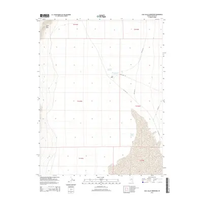
2014 Map of Coal Valley Reservoir
USGS Topo · Published 2014About this map
The eastern slopes of the Golden Gate Range descend into the high desert basin of Coal Valley in this topographic study of Lincoln County. The landscape is defined by its arid water management systems, including the Coal Valley Reservoir, Sheep Reservoir Number 2, and the larger East Coal Valley Reservoir. A sparse network of primitive routes, including Coal Valley Rd and Oreana Spring Rd, provides the only access through these expansive grazing lands and public sections. This 2014 data reflects the persistent ranching and range infrastructure of the Great Basin, where name-specific roads like Upper Hole Rd lead toward remote springs and catchment basins essential for livestock in the Nevada interior.
Find a feature on this map
15 named features on this map. Tap any name to fly to it.
Don’t see what you’re looking for? This feature index may not catch every label — zoom into the map to look around manually.
Map Details
Editions of this 2014 Coal Valley Reservoir Map
This is the sole edition of this map. No revisions or reprints were ever made.
Other maps of this area

1954 · Caliente
USGS Topo · 1:250,000

1956 · Lund
USGS Topo · 1:250,000

1959 · Caliente
USGS Topo · 1:250,000

1960 · Lund
USGS Topo · 1:250,000

1970 · Oreana Spring
USGS Topo · 1:24,000

1970 · Seaman Wash
USGS Topo · 1:24,000
1971 · Timber Mtn Pass West
USGS Topo · 1:24,000

1985 · Water Gap East
USGS Topo · 1:24,000

1985 · Coal Valley Reservoir
USGS Topo · 1:24,000

1985 · Murphy Gap
USGS Topo · 1:24,000