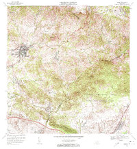
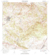
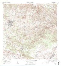
1972 Map of Coamo
USGS Topo · Published 1973About this map
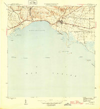
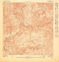
The town of Coamo serves as the central hub of this 1970s landscape, situated where the southern foothills meet the Cordillera Central. The terrain is defined by a series of prominent peaks including Cerro Santa Ana and Cerro Presidio, which overlook the winding course of the Río Coamo. This era shows a mix of traditional agricultural heritage and modern institutional development, evidenced by the presence of both the historic Hacienda Buena Vista and the Puerto Rico National Guard facility within the Salinas Training Area. Local education is anchored by the Escuela Federico Degetau, while the southern reaches of the map near the Río Jueyes show organized residential settlements like Parcelas Peñuelas. A Pista De Aterrizaje and multiple radio antennas indicate the infrastructure of the period, while the Baños de Coamo remain a notable landmark for the region's natural springs.
Find a feature on this map
52 named features on this map. Tap any name to fly to it.
Don’t see what you’re looking for? This feature index may not catch every label — zoom into the map to look around manually.
Map Details
Editions of this 1972 Coamo Map
3 editions found
Other maps of this area

1944 · Santa Isabel
USGS Topo · 1:30,000

1945 · Rio Descalabrado
USGS Topo · 1:30,000
1945 · Central Aguirre
USGS Topo · 1:30,000
1945 · Salinas
USGS Topo · 1:30,000

1946 · Coamo
USGS Topo · 1:30,000

1946 · Barranquitas
USGS Topo · 1:30,000

1946 · Cayey
USGS Topo · 1:30,000

1946 · Comerio
USGS Topo · 1:30,000

1946 · Orocovis
USGS Topo · 1:30,000
1947 · Cayey NO
USGS Topo · 1:10,000