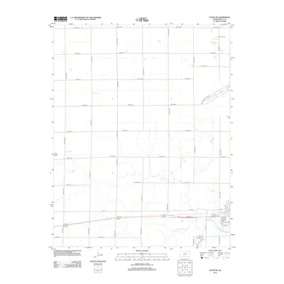
2012 Map of Coats NE
USGS Topo · Published 2012About this map
The S Fork Ninnescah River meanders through the southern half of this landscape, its drainage patterns defining the breaks in an otherwise orderly grid of section lines and gravel roads. In the northeast, industrial activity is marked by the Chance Oil Field, while the Pratt Municipal Airport occupies a significant footprint in the east-central portion of the quadrangle. High points like Pilot Knob stand above the surrounding agricultural fields, which are strictly partitioned by an extensive network of thoroughfares such as NW 70th St and NW 70th Ave. Recent residential developments or subdivisions are visible near the river's bend, indicated by the winding paths of SW Lakeview Dr and SW Eastridge Rd, showing the modern expansion of the area surrounding Pratt at the beginning of the 2010s.
Find a feature on this map
39 named features on this map. Tap any name to fly to it.
Don’t see what you’re looking for? This feature index may not catch every label — zoom into the map to look around manually.
Map Details
Editions of this 2012 Coats NE Map
This is the sole edition of this map. No revisions or reprints were ever made.
Other maps of this area

1892 · Pratt
USGS Topo · 1:125,000

1894 · Pratt
USGS Topo · 1:125,000

1955 · Pratt
USGS Topo · 1:250,000

1959 · Pratt
USGS Topo · 1:250,000

1968 · Pratt SW
USGS Topo · 1:24,000

1968 · Pratt
USGS Topo · 1:24,000

1968 · Cullison
USGS Topo · 1:24,000

1968 · Coats
USGS Topo · 1:24,000

1968 · Coats NE
USGS Topo · 1:24,000
1968 · Croft
USGS Topo · 1:24,000