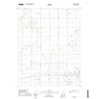
2018 Map of Coats NE
USGS Topo · Published 2018About this map
The S Fork Ninnescah River meanders across the southern portion of this landscape, just south of the developing outskirts of Pratt. This 2018 survey documents the city's northwestern expansion, where the grid of the Pratt townsite meets the broad agricultural sections of Pratt County. To the northwest, the prominent Pilot Knob rises as a distinct landmark above the surrounding plains. The local infrastructure is anchored by the Pratt Municipal Airport in the northeast and a systematic network of section-line roads, such as NW 70th St and NW 20th St. This map illustrates the intersection of modern aviation and traditional Kansas agriculture at the edge of a vital regional hub.
Find a feature on this map
25 named features on this map. Tap any name to fly to it.
Don’t see what you’re looking for? This feature index may not catch every label — zoom into the map to look around manually.
Map Details
Editions of this 2018 Coats NE Map
This is the sole edition of this map. No revisions or reprints were ever made.
Other maps of this area

1892 · Pratt
USGS Topo · 1:125,000

1894 · Pratt
USGS Topo · 1:125,000

1955 · Pratt
USGS Topo · 1:250,000

1959 · Pratt
USGS Topo · 1:250,000

1968 · Pratt SW
USGS Topo · 1:24,000

1968 · Pratt
USGS Topo · 1:24,000

1968 · Cullison
USGS Topo · 1:24,000

1968 · Coats
USGS Topo · 1:24,000

1968 · Coats NE
USGS Topo · 1:24,000
1968 · Croft
USGS Topo · 1:24,000