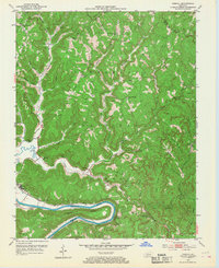
1952 Map of Cobhill
USGS Topo · Published 1968About this map
The Kentucky River winds sharply through the southern reaches of this Kentucky landscape, defining the industrial and social patterns of the early 1950s. Near the river, the Louisville and Nashville railroad tracks follow the northern bank, connecting river settlements like Old Landing and Shade to the wider region. The terrain is characterized by intricate drainages like Big Sinking Creek and Furnace Fork, where numerous oil wells dot the ridges, signaling the persistent energy extraction that defined the local economy during this era.
Find a feature on this map
60 named features on this map. Tap any name to fly to it.
Don’t see what you’re looking for? This feature index may not catch every label — zoom into the map to look around manually.
Map Details
Editions of this 1952 Cobhill Map
3 editions found
Other maps of this area

1892 · Beattyville
USGS Topo · 1:125,000

1952 · Leighton
USGS Topo · 1:24,000

1952 · Clay City
USGS Topo · 1:24,000

1952 · Stanton
USGS Topo · 1:24,000

1952 · Slade
USGS Topo · 1:24,000

1952 · Beattyville
USGS Topo · 1:24,000

1952 · Cobhill
USGS Topo · 1:24,000

1952 · Heidelberg
USGS Topo · 1:24,000

1952 · Irvine
USGS Topo · 1:24,000

1953 · Zachariah
USGS Topo · 1:24,000