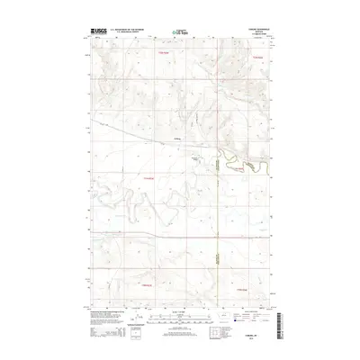
2014 Map of Coburg
USGS Topo · Published 2014About this map
The small settlement of Coburg serves as a focal point in this 2014 survey of the Big Sky landscape, situated where the Milk River valley meets the northern plains of Montana. The Milk River winds through the center of the sheet, its path mirrored by irrigation infrastructure like the Main Canal, which reflects the region's agricultural dependency on managed water resources. Transport and transit routes are clearly defined by the crossing at Milk River Bridge and the path of Us-2, which parallels the river as it moves through the county. The map also delineates the jurisdictional boundary between Blaine Co and Phillips Co, a detail of significant interest to local researchers. Drainage patterns across the terrain are traced through smaller waterways such as White Bear Creek, Milk Cr, and Peoples Cr, showing the intricate hydrology that supports this rural expanse.
Find a feature on this map
23 named features on this map. Tap any name to fly to it.
Don’t see what you’re looking for? This feature index may not catch every label — zoom into the map to look around manually.
Map Details
Editions of this 2014 Coburg Map
This is the sole edition of this map. No revisions or reprints were ever made.
Other maps of this area

1903 · Wayne Creek
USGS Topo · 1:62,500

1905 · Wayne Creek
USGS Topo · 1:62,500

1913 · Cherry Ridge
USGS Topo · 1:125,000

1920 · Avery
USGS Topo · 1:125,000

1953 · Havre
USGS Topo · 1:250,000

1957 · Havre
USGS Topo · 1:250,000

1958 · Havre
USGS Topo · 1:250,000

1964 · Wayne Creek SE
USGS Topo · 1:24,000

1964 · Coburg
USGS Topo · 1:24,000

1964 · Coburg SE
USGS Topo · 1:24,000