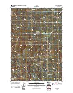
2011 Map of Cochran
USGS Topo · Published 2011About this map
Cochran and the surrounding timberlands of the Northern Oregon Coast Range define this landscape, where steep topography is carved by an intricate network of waterways. The settlement at Cochran sits at a high point near Cochran Pond, marking a historic nexus for rail and logging operations that historically moved timber from the Salmonberry River and South Fork Nehalem River drainages. A dense system of forestry roads, including Storey Burn Rd and the Standard grade, crisscrosses the slopes of Larch Mountain and Giveout Mountain.
Find a feature on this map
35 named features on this map. Tap any name to fly to it.
Don’t see what you’re looking for? This feature index may not catch every label — zoom into the map to look around manually.
Map Details
Editions of this 2011 Cochran Map
This is the sole edition of this map. No revisions or reprints were ever made.
Other maps of this area

1937 · Enright
USGS Topo · 1:62,500

1939 · Saddle Mountain
USGS Topo · 1:62,500

1941 · Keasey
USGS Topo · 1:62,500

1941 · Timber
USGS Topo · 1:62,500

1941 · Enright
USGS Topo · 1:62,500

1943 · Keasey
USGS Topo · 1:62,500

1943 · Saddle Mtn.
USGS Topo · 1:62,500

1948 · Vancouver
USGS Topo · 1:250,000

1950 · Vancouver
USGS Topo · 1:250,000

1950 · Vancouver
USGS Topo · 1:250,000