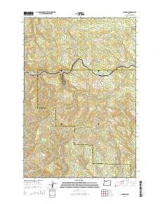
2014 Map of Cochran
USGS Topo · Published 2014About this map
Cochran marks the central hub of this remote timber and mountain landscape on the border of Washington and Tillamook Counties. The settlement is centered near Cochran Pond at the headwaters of the Salmonberry River and the S Fork Nehalem River. The map reveals a complex network of forest roads and topographic landmarks, including the notable peaks of Giveout Mtn and Larch Mtn. This area is defined by its dramatic elevation changes and a dense web of drainages like Idiot Cr and Gales Cr. Local infrastructure is represented by routes such as Standard Grds and Belding Rd, which historically supported the logging operations in the Oregon Coast Range. Researchers can trace the winding paths of numerous named creeks that feed into the larger river systems of the region.
Find a feature on this map
37 named features on this map. Tap any name to fly to it.
Don’t see what you’re looking for? This feature index may not catch every label — zoom into the map to look around manually.
Map Details
Editions of this 2014 Cochran Map
This is the sole edition of this map. No revisions or reprints were ever made.
Other maps of this area

1937 · Enright
USGS Topo · 1:62,500

1939 · Saddle Mountain
USGS Topo · 1:62,500

1941 · Keasey
USGS Topo · 1:62,500

1941 · Timber
USGS Topo · 1:62,500

1941 · Enright
USGS Topo · 1:62,500

1943 · Keasey
USGS Topo · 1:62,500

1943 · Saddle Mtn.
USGS Topo · 1:62,500

1948 · Vancouver
USGS Topo · 1:250,000

1950 · Vancouver
USGS Topo · 1:250,000

1950 · Vancouver
USGS Topo · 1:250,000