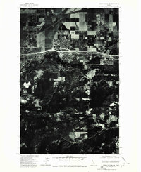
1975 Map of Coeur D'Alene NW
USGS Topo · Published 1980About this map
Post Falls stands at the heart of this mid-1970s orthophotoquad, showcasing the transition from agricultural grid patterns to suburban development along the northern bank of the Spokane River. The aerial perspective reveals the distinct rectangular parceling of land north of the city, contrasted by the more complex, wooded topography found to the south. Along the southern portion of the quadrangle, the winding path of Cougar Creek cuts through the dark, forested hills, providing a sharp visual counterpoint to the growing townsite. This map captures a pivotal moment of expansion for the region, where new transportation corridors and residential streets begin to push into formerly rural areas, all while the primary waterway remains the defining geographic feature of the landscape.
Find a feature on this map
3 named features on this map. Tap any name to fly to it.
Don’t see what you’re looking for? This feature index may not catch every label — zoom into the map to look around manually.
Map Details
Editions of this 1975 Coeur D'Alene NW Map
This is the sole edition of this map. No revisions or reprints were ever made.
Other maps of this area

1901 · Spokane
USGS Topo · 1:125,000

1903 · Rathdrum
USGS Topo · 1:125,000

1943 · Mt Spokane
USGS Topo · 1:62,500

1949 · Greenacres
USGS Topo · 1:62,500

1950 · Mt Spokane
USGS Topo · 1:62,500

1951 · Greenacres
USGS Topo · 1:62,500

1955 · Spokane
USGS Topo · 1:250,000

1957 · Coeur D'Alene
USGS Topo · 1:62,500

1958 · Spokane
USGS Topo · 1:250,000

1961 · Hayden
USGS Topo · 1:24,000