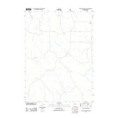
2011 Map of Coffee Mill Butte SW
USGS Topo · Published 2011About this map
Highland Center Cemetery sits at the northeastern edge of this Dawes County landscape, a marker of the enduring rural communities in the Nebraska Panhandle. The terrain is defined by a dense network of seasonal drainages, including the branching headwaters of Cottonwood Creek, Willow Creek, and East Ash Creek. These watercourses dictate the layout of the local transport network, where long straight stretches like Section Line Rd and Table Rd give way to more winding routes such as Hollibaugh Rd as they navigate the breaks. This 2011 survey documents a sparsely populated ranching or agricultural region where the names of early settlers remain preserved on the land through landmarks like W Ash Creek Rd and Hough Rd.
Find a feature on this map
14 named features on this map. Tap any name to fly to it.
Don’t see what you’re looking for? This feature index may not catch every label — zoom into the map to look around manually.
Map Details
Editions of this 2011 Coffee Mill Butte SW Map
This is the sole edition of this map. No revisions or reprints were ever made.
Other maps of this area

1946 · Box Butte Reservoir West
USGS Topo · 1:24,000

1948 · Box Butte Reservoir West
USGS Topo · 1:24,000

1948 · Box Butte Reservoir East
USGS Topo · 1:24,000

1951 · Marsland
USGS Topo · 1:62,500

1955 · Alliance
USGS Topo · 1:250,000

1957 · Alliance
USGS Topo · 1:250,000

1958 · Alliance
USGS Topo · 1:250,000

1980 · Crow Butte
USGS Topo · 1:24,000
1980 · Coffee Mill Butte SE
USGS Topo · 1:24,000
1980 · Coffee Mill Butte
USGS Topo · 1:24,000