
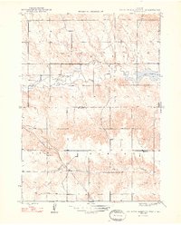
1948 Map of Box Butte Reservoir West
USGS Topo · Published 1948About this map
The Niobrara River flows eastward across this high plains landscape, feeding into the western reaches of the Box Butte Reservoir. This mid-century survey by the Bureau of Reclamation and the Geological Survey documents a remote stretch of the Dawes and Box Butte County line shortly after the reservoir's creation. The southern portion of the map is defined by the winding route of the Chicago Burlington and Quincy railroad, which cuts through the topography near Sand Canyon. Rural education centers such as Sch No 50 and Sch No 52 serve the surrounding townships of Leonard and Lawrence. The map's detailed contouring reveals the transition from the flat river valley and reservoir basin to the complex drainage patterns of Willow Creek and the surrounding breaks.
Find a feature on this map
10 named features on this map. Tap any name to fly to it.
Don’t see what you’re looking for? This feature index may not catch every label — zoom into the map to look around manually.
Map Details
Editions of this 1948 Box Butte Reservoir West Map
2 editions found
Other maps of this area

1946 · Nonpareil
USGS Topo · 1:24,000

1946 · Box Butte Reservoir West
USGS Topo · 1:24,000

1948 · Hemingford
USGS Topo · 1:24,000

1948 · Nonpareil
USGS Topo · 1:24,000

1948 · Box Butte Reservoir East
USGS Topo · 1:24,000

1951 · Marsland
USGS Topo · 1:62,500

1955 · Alliance
USGS Topo · 1:250,000

1957 · Alliance
USGS Topo · 1:250,000

1958 · Alliance
USGS Topo · 1:250,000
1980 · Coffee Mill Butte SE
USGS Topo · 1:24,000